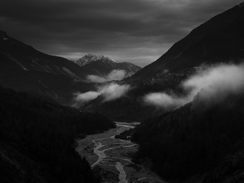
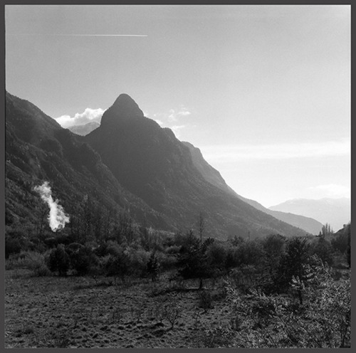
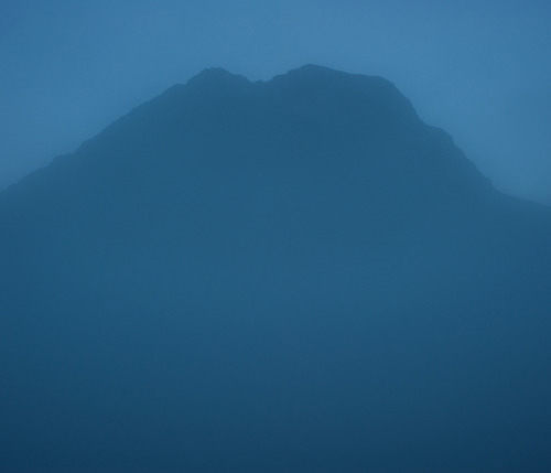
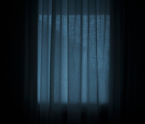
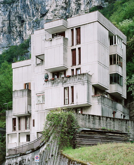
© Andrea Alessio, ‘Vajont - 10.39pm - 46,267223 12,328889’
One of the reasons that brought me closer to photography is the widespread use of this medium to document and describe land and territories. The ability to synthesize and express the complexity of territories is also the basis of the large public recognition of a photographic action in favor of the land management. Photography therefore no longer mainly didactic or illustrative, but a practical function of observation of the landscape that both complements other traditional instruments and disciplines in the study of territorial transformations, and potentially affect the design thinking. The experience gained in this respect are numerous, sometimes questionable, however, they testify the increasing role of a commissioning, or at least of a sensibility.
Furthermore it must be said that photography as other visual languages offers new views and possibilities of interpretation and reading of the landscape and its history. In this perspective, I find it interesting to introduce the ongoing project ‘CALAMITA/A’ edited by Gianpaolo Arena and Marina Caneve. A dialogue and a survey on the area of Vajont in Italy, a valley known mostly for the environmental disaster that struck in 1963 and for the political negligence that caused this event. I asked them to describe the reasons and outcomes of this experience, and to give voice to some of the authors involved. A research that I would define as “bottom up” because it’s a independent cultural format. It is in fact a good practice of participation and an example that I hope will flourish in other territories.
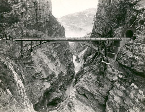
© Bridge on the Vajont river - Longarone (BL) -1956. View … river near Longarone. (Carlo Pradella photo archive)
© Andrea Botto
Let’s start from the interdisciplinary nature of the project CALAMITA/A’. Why this curatorial choice and what difficulties have you encountered developing it?
Gianpaolo Arena e Marina Caneve (GA MC): Both architects and photographers, we are convinced of the importance of building an articulate and complex vision of our territory. Our main intention was, since the beginning of the project, to generate reactions between projects involving different disciplines, languages and mediums with the will to make them dialogue openly. A collective project where individuality and identity participate actively in the analysis and interpretation of the territory. Since the beginning we have worked to generate a debate on the subject, by relating on the same platform several disciplines and languages. For us Vajont was a great challenge. The story of a territory marked by a tragic history and for this highly attractive. Almost a dangerous and cathartic attraction for a landscape of impenetrable mystery. A sensation so well described and narrated by Peter Weir in ‘Picnic at Hanging Rock’ (1975).
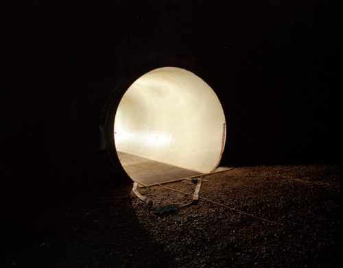
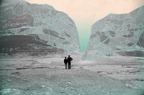
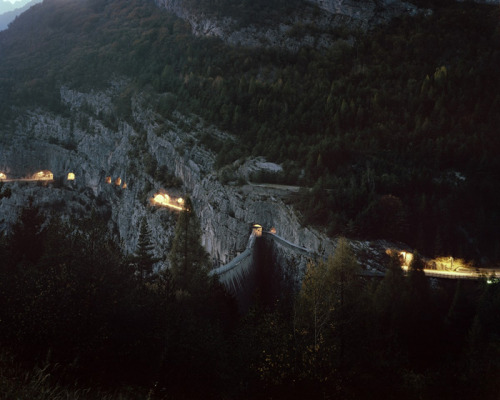
© Gianpaolo Arena, Collapsing Stars
What interested us considerably was how the perception of the tragedy and the mutation of the territory has changed. We asked the participating authors to interpret the territory and space and to create a new reading of the catastrophic event. Memory preservation is important, but it must be placed in relation with what is contemporary and what has been built over the last 50 years. Two years after the launch of CALAMITA/A’ we are still convinced of the contribution that a multidisciplinary and open approach can give to a project about a territory. As curators, we wanted to design an online platform where contents could be displayed in the best possible manner. On the website, since the beginning, we have chosen to show on-going projects, asking the authors to work in relatively long periods of time evolving their projects.
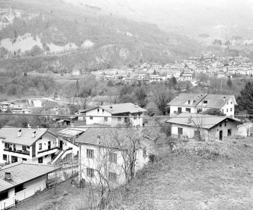
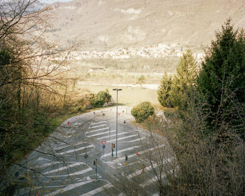
© Alfonso Chianese, Nel Vajont
© Julia Geiser, ‘Vajont’
This decision comes from the idea of sharing their research and increasing their work by studying the other projects. The main interest is in fact to build an evolving project, within which the authors who put it together emerge, but most of all to create a collective and shared vision. The difficulties we have encountered coordinating all these authors have been mainly logistic and related to the variety of mediums used. Before starting we established a dossier with different information about the tragedy and the territory to be given to the authors. We didn’t receive the logistic and economic support that we hoped. Believing in what what we were able to build during these years, we are convinced that the situation will evolve in this direction. CALAMITA/A’ is a large organic laboratory about territory, which uses the web to convey information, to generate debates and interaction, to state assumptions and possible itineraries.
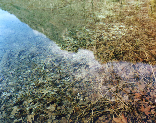
© Marina Caneve, ‘Motherboard’
This year the project received an important recognition with the selection and participation at the Swiss festival Alt. + 1000. Tell us about this experience? What kind of feedback have you received from experts and from the public opinion?
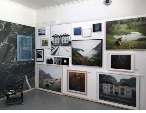
(GA MC): Alt. + 1000 – now in its fourth edition – is a festival tied to the mountain, especially mountain photography. After hosting authors such as Olivo Barbieri, Simon Norfolk, Simon Roberts, Awoiska van der Molen, Olaf Otto Becker, Matthieu Gafsou… many of which have been published on our platform, the festival management identified “Territory” as its theme. A jury of curators and photography and contemporary art experts such as Béatrice Andrieux, Raphaël Biollay, Matthieu Charon, Pierre Geneston, Catherine Gfeller, Nathalie Herschdorfer, have selected us among 187 candidates. The exhibition project we proposed was developed during the experience of the exhibition held last September as part of Laboratorio Italia at the SI Fest in Savignano sul Rubicone, by Massimo Sordi and Stefania Rossl; the installation was conceived as a proposal for an ongoing, where the territory has a great importance and is put in relation with the projects of the authors. This is the reason why we used a large wallpaper that showed an aerial view of the “Vajont territories”.
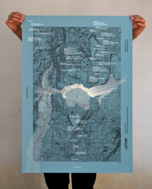
© Latitude Platform
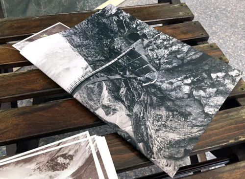
We wanted to relate the aerial view with a silk-screen print from Latitude Platform, an urbanism and research studio on the theme of water, and in contrast, we used a white wall as the creation site of our vision of the territory. A manner which puts in a close relation a scientific and objective view with an emotional and subjective approach. Our experience with the Festival was very positive. It represented an important evolution of the exhibition project and the opportunity to create a Newspaper, to be distributed to the visitors of the festival, with interviews conducted during the past year. During the opening of the Festival we had the opportunity to discuss the project with the director of the Festival Béatrice Andrieux, with whom we built the exhibition idea from January to June; with Nathalie Herschdorfer, curator of the festival and director of the Musée de Beaux Arts de Le Locle, with Marco Costantini, chief director of the Festival Alt. + 1000 and current director of MUDAC, with professors from the ECAL of Losanna and many academics, journalists and professionals in the field of territorial transformations. We were very impressed by the interest the public showed towards the tragic story of Vajont and towards the project itself.
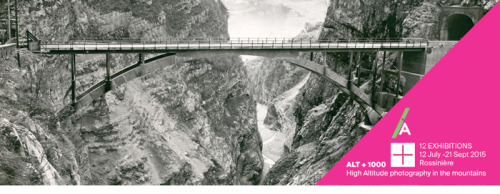
© Alt. + 1000 Festival
The project has collected so far an important adhesion. What will be the future developments of the project also in relation to the communication and distribution of the research?
The network has conquered an international dissemination and visibility. Daily we receive submissions coming from photographers around the world. The project depending on the context, the demands and goals can be declined as an exhibition, as editorial and can develop itself through educational activities and research. The Collateral section will have new developments and updates; currently it is hosting the works of international authors such as Zhang Kechun, Yurian Quintanas Nobel, Jürgen Nefzger, Benoit Aquin, Mitch Epstein, Edward Burtynsky, Gareth Phillips, Ian van Coller, Marion Belanger, Pétur Thomsen, Pascal Amoyel, Yannik Willing, François Deladerrière, Bärbel Praun, Richard Petit, Céline Clanet. The section dedicated to thematic interviews, will be central to the project and strongly declined towards current geopolitics, with some insights on topics such as disasters and calamities, territorial and urban transformations, dynamic identities, climatic changes, the global market, architecture, the tourism industry, ecologic issues, migration and social marginality and minorities. In addition to those already published with Derrick De Kerckhove, Olaf Otto Becker, Matthieu Gafsou, Simon Norfolk, Rob Stephenson, Drew Nikonowicz, William Basinski, Aglaia Konrad, new contributions will be added soon edited by Camilla Boemio, Niccolò Fano and Roberta Agnese. Given the social, documentary and participating nature of a project which involves, even emotionally, many people, it’s possible to develop a crowfunding platform which will allow us to create a series of activities in different directions: publications, contests, presentations. The ‘inadequate reaction’ of corporations and institutions to support this project economically offers this type of direction. The participation and interest that CALAMITA/A’ has raised in the last two years gives us hope.
What are you thinking for the future, we know there is the idea of an editorial project. What is it about?
The publication aims to be a point of arrival where we unveil what has been created since 2013 to today. The authors involved have generously spent a lot of energy creating their projects on the Vajont territory. At the same it will be a new beginning to trigger synergies, collaborations, theories for itineraries. The idea is to combine site specific photographic projects with an apparatus of critical texts and essays on the subject of catastrophes, as well as an excerpt of the interviews developed on the same theme. A sort of interdisciplinary and organic mapping of the territory where photography, still remaining the preferential tool of investigation, overlaps and relates with other disciplines and instruments.
© Marco Lachi, ‘Protti’s Wood’
…
INTERVIEWS WITH PHOTOGRAPHERS
a. Why a project on Vajont? What were the initial motivations and how did the research develop?
b. Vajont as a historical event weighs on current reality and inevitably on its transcription, description and representation. How much has this relationship affected the project?
c. Photography can act as a tool of investigation and analysis complementing traditional practices of urban and territorial planning. What is the personal contribution of your project to the interpretation of this territory?
d. Landscape doesn’t exist, but the idea of landscape that each of us have does. This creates a space for dialogue. The photographer can show through his work an interpretation of the landscape highlighting aspects of social and civil nature. Which elements and features of the landscape did you want to trace with your point of view?
1. SERGIO CAMPIONE
a. I accepted the invite of Marina Caneve and Gianpaolo Arena with much enthusiasm and many uncertainties, in front of an unknown and complex territory such as Vajont. With 50 years of investments, speculations, trials and social disasters, why not do a research on the Vajont! Initially I was following other routes, let’s say, mostly forensic. Starting from some documents I wanted to reconstruct photographs, as if to mark the probatory aspect. The intention was to make multiple orders (geological, legal, military, economic, urban and anthropologic) interact and to highlight the conflicts and their showcase. Then during my stay in Longarone I became more interested in the contemporary aspect, leaving in the background the historical part and looking for an urban landscape highly fragmented and ambiguous as the Vajont territories.
© Sergio Campione, Breviario di un paesaggio incompleto
b. The historical events of Vajont are very complex, made of mysteries intertwined with politics and the nationalization of electricity, which occurred “coincidently” with the catastrophe. To understand how Italy was during the 50s and 60s and what price it had to pay for progress, as always you have to look to art and intellectuals. So the harsh Italian society of the 50s doesn’t appear in the least out of place, as it was narrated by Italo Calvino with the “industry speculation” of ’57, with the social climbing of the middle class, of which Pierpaolo Pasolini wrote and said much about and then, during the year of Vajont Italian cinema gives birth to one of its most important masterpieces on civil commitment with “Le mani sulla città” by Francesco Rosi. The city is the Naples of Achille Lauro, and the hands are those of a real estate speculator who managed to change the city’s planning.
© Sergio Campione, Breviario di un paesaggio incompleto
c. If we decide that photography is a political fact then it is certainly one of the best tools to interpret contemporary society with its desires of appropriation. On my personal behalf, I have no certainty. I only believe that placing doubts is the only narrative form that i wish to achieve.
d. If a landscape to exist needs someone to see it, it is certainly true that we recognize a landscape only if it concerns us and is generated by collective memory. We must then understand how memory itself interprets or enhances the physical space of places. In Vajont’s case collective memory has been almost completely erased and as if the tragedy of ’63 has obscured everything, leaving only the memory of itself, fragmented and ambiguous. The only place where it is strongly alive with traces of the landslide still very evident, is the “old forest” as the inhabitants of Erto-Casso call it. Here we can read time, the geological time and the resilience of nature. Adding and accumulating traumas without removing them, after all, is a completely “natural” talent.
…
2. MICHELA PALERMO
a. I have being interested in photography with events that have had a collective impact or significance, looking to them through my personal perspective. I engage my vision with elements such landscapes or observed portraits looking for traces –better say echoes- of such facts. One of my former project ‘My broken world’ was about the earthquake in Irpinia: after 30 years from the aftermath I went back and I looked for signs of this change. Widely I consider the earthquake of 1980 in Irpinia as a switch from a rural to a sort of postindustrial world, a phenomenon that’s been affecting also the area of Vajont. So the opportunity to research for CALAMITA/A’ project, has seemed both to the curators than me as an interesting challenge to move forward in my work.
© Michela Palermo, ‘Where you go I go too’
b. I’m just about starting my project, but I believe the historical aspect will be an important pivotal in my approach. My background is in Political Studies and the tragedy of the dam was the fact which cracked the social contract in the local community and had a strong reverb in the national frame. I’m particularly interested for this kind of rip and to use the historical background as a scaffold for constructing my narrative.
c. The disaster of Vajont crushed in few moments a story of millennium considering the landscape, but also the economical and social structures in the area. I consider photography in its fragmented essence an important tool to reflect about the idea of territory, due to its inner capacity of travelling through space and time.
© Michela Palermo, ‘Where you go I go too’
d. I think I have being particularly influenced by the tales I heard about the moments of the tragedy, when in few minutes the landscape and everything connected to it has changed forever. I chose the word “submerged”, and through it I took a first step in order to envision my story of Vajont: it was a first kick, I’m looking forward to seeing where it will lead me.
…
3. GABRIELE ROSSI
a. For a long time I have been interested in human action on territory and have tried to translate the consequences through a system of images which tend to help me revisit the past and to generate a hypothesis on the present. When I arrived at Longarone I was stricken by a still landscape, frozen in tragedy. Through three referential sections identified as the valley, the dam and all that remains behind I built an imaginary line, a sort of rewind visible on a magnetic tape.
b. Representing a landscape through photographic means often generates foregone conclusions and stereotypes caused by misinterpretations. In my opinion a landscape and its historical evaluation can be imagined as a wall or better yet as an iconostasis to be completed without the need to be worshiped.
© Gabriele Rossi, ‘Concrete Cluster’
c. Does narrating a territory more than 50 years after a disaster that has devastated it make sense? I believe all my work can be attributed to a single descriptive procedure which tends to clearly show the state of things. Everything is changed and nothing is as before. This large uncertainty that haunts me creates an obsession, a state of fundamental crisis to tell what Vajont is for me today.
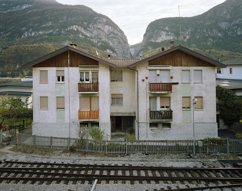
© Gabriele Rossi, ‘Concrete Cluster’
d. When you narrate a landscape though its features, everything is an influence, from the light there is in that moment to what we discovered from a prior documentation. Through probing actions, borrowed from geological surveying techniques I wanted to mark isolated points scarcely attributed among them except through the perpetual sign of nature on landscape. The altitudes collapse and nature’s more concrete layers follow them.
…
4. CYRILLE WEINER & GIAIME MELONI
a. It is not purely a project on the Vajont. Of course the images produced provide a tangible proof of our presence in the territory, in a certain way they documented it. However the identity characteristics of this place, anchored in recent history, mean that the project can assume a more universal dimension of visual search. We started a direct exploration by seeking strong characteristics that can be declined as a paradigm. This approach allowed us to take distance compared to the documentation - and strictly documentary photography - in order to provide a more universal reflection on our relationship with the world. In fact the Vajont acts as a paradigm: a territory stigmatized by a human and natural disaster. The starting point of this work was to reflect on the broader definition of disasters. Paul Virilio’s quote : “A civilization that implements immediacy, the ubiquity and immediacy, staged the accident, the catastrophe” is the key to reading the project ‘Banale e Brutale’. This phrase has allowed us to activate a reflection necessary for the development work. The observation of the French philosopher lets understand the human necessity of staging the accident and the disaster. From this observation about the media coverage of the disaster we have built a sensible definition by creating a work able to mix text and images. It became clear, developing the project, to produce a newspaper that can reconstruct, in a fictional way, the staging of the disaster.
The events we have chosen to create the newspaper ‘Banale e Brutale’ are minor facts/minor disasters that populate the pages. The gap created by hiding the main event, on a visual level reading, allowed us to focus attention on the confrontation of nature with culture, about how man produces obvious marks on the territory such as disasters.
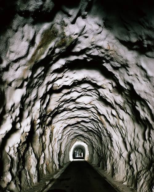
© Cyrille Weiner & Giaime Meloni, ‘Banale e Brutale’
b. For us was important to understand and to hesitate on the cycle of destruction and reconstruction of the country, because it is constantly undergoing revolutionary and evolutionary transformations. The identification of two distinct phases allowed us to stop time on an uncertain temporality a temporary fragment trapped between it is not and it is not yet. Our direct experience of the territory has caused a visual interest and curiosity for strong signs that marked the territory. First the massive strength of the dam, stigma and reason of the disaster, express its maximum power from its brute/brutal/brutalist identity. The monolithic presence of the dam gave a possible key to reading this space we strongly connoted by the presence of concrete, imposed on the Vajont, alternating construction and destruction phases. This material is banal, for the simplicity of its realization, and brutal, for its texture and color, comes to us as a filter in the landscape’s reading. The name of ‘Banale e Brutale’ project recovers this double quality of concrete as a metaphor of any material of construction but also an element capable of harmonizing violence and the fragility of this place.
c. The visual experience of the places through the images, which we realized on the Vajont, certifies the active role of photography as a discipline of landscape’s studies. Concretely we have developed a photographic pratice as a tool for visual auscultation of material and immaterial Vajont’s transformations.
The intellectual solicitation of immersive action on the territory allows us to assert that photography can be considered a discipline of study and practice of landscape, between geography and architecture. However in contrast to other disciplines, photography does not give answers but raises new questions. It can be defined as a continuous verification process for the landscape’s evolution. The images of ‘Banale e Brutale’ project makes possible to qualify spaces. Qualifier is to give them a quality that can be very different stereotypes, offer a new reading, to look at things that are often neglected. Rather than giving to see things as they are the subjacent message of our work ‘Banale e Brutale’ wants to go beyond the superficial relationship of photography to reality. The photos aims to prove that there is an implicit message exceeding the limits of the image itself. We accept that the message of the images can be corrupted / destroyed at any time by the viewer / reader of ‘Banale e Brutale’. Indirect experience through our images can reproduce new knowledge of the Vajont.
© Cyrille Weiner & Giaime Meloni, ‘Banale e Brutale’
d. When operating on a specific territory, such as the Vajont, our gaze was lingered on the peculiars aspects of the place : the banal and brutal material which gave the key to reading for visual approach to interpretation of the landscape. Fragmentation operated by the images results in multiple definition, because indeed the landscape as a unit exists only in our minds. Photographic practice has identified the main aspects of the landscape: the plurality of their identities. We can not speak of a single landscape we have rebuilt in ‘Banale e Brutale’ project because it is already a plural work led by two different people. The richness of the project finds its strength in the will to rebuild multiple landscapes from a collective experience on the territory. In conclusion, this sensitive and intellectual concern visual action can be entered as a test re - Production of the landscape (S) through the construction of various fragments.
…
5. LATITUDE PLATFORM
a. The Vajont represents maybe one of the most tragic and paradigmatic man-driven disaster that has affected the Italian territory in the last century. Latitude’s recent researches on how urbanisation can cope with environmental risks and the need to find a fertile collaboration with engineers, plus the anniversary of the Vajont have been the starting point.
b. It has been fundamental to “give voice” and “shape the body” of the artworks that Latitude has produced so far. The representation of the mechanics of the tragedy - landslide and wave - in an abstract (model) or contextual (serigraphy) way are meant to be two invitations to look at the present through measurable images of the past.
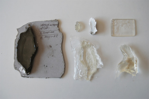
© Latitude Platform, CALAMITA/A’
c. In the serigraphy Latitude has overlapped different spaces - thanks to transparencies and layers - and times - representing various moments at once through images and text - aiming at producing a multilayered measurable image. Similarly, the model shows the pure shapes and quantities of material (water, soil) involved in the disaster which are never represented as such.
d. Our work starts from the technical and measurable representations of the landscape (cartography, engineering drawings, data) highlighting the link and the distance between the dry, objective images of the territory and the “emotional geography” derived from the disaster. Thus, the attention is posed on the visible and invisible elements of the landscape that echo of the tragedy.
Translation curated by Asia Trianda
LINKS
CALAMITA/A’
Italy
share this page